Central America Maps
Central America is located in the center of the American continent and is surrounded by two oceans: the Pacific and the Atlantic. Central America is divided into seven independent countries, in addition to Insular Central America. Below we show you its political division, its physical resources, hydrography and the section of the Pan-American Highway that corresponds to it.
Below you have an index with all the points that we are going to deal with in this article.
Table of Contents
- 1.
- 2.
- 3.
- 4.
Political map
The political division of Central America is made up of a total of seven independent countries:
- Belize
- Costa Rica
- El Salvador
- Guatemala
- Honduras
- Nicaragua
- Panama
The center of the American continent is located specifically between the southern border of Mexico and the western border of Colombia.
In accordance with this political division, below we show in a table what is the territorial extension of each country, as well as the capital of each one:
| Country | Capital | Territorial extension (km²) |
| Belize | Belmopan | 22.966 |
| Costa Rica | San Jose | 51.100 |
| El Salvador | San Salvador | 21.041 |
| Guatemala | Guatemala City | 108.894 |
| Honduras | Tegucigalpa | 112.492 |
| Nicaragua | Managua | 129.494 |
| Panama | Panama | 78.200 |


For its part, Insular central america, a territory also known as the Antilles or the Caribbean, is made up of an extensive number of archipelagos made up of the Greater Antilles, the Lesser Antilles and the islands of the Bahamas or Lucayas. This region of Central America is located between the Caribbean Sea and the Atlantic Ocean and, together, they form an arc that goes from Florida (USA) and the east of Yucatán (Mexico) to the west coast of Venezuela.
Below we show you the independent countries that make up insular Central America along with its capital and its surface:
| Country | Capital | Territorial extension (km²) |
| Antigua and Barbuda | St. John's | 440 |
| Bahamas | Nassau | 13.939 |
| Barbados | Bridgetown | 430 |
| Cuba | Havana | 410.922 |
| Dominica | Reed | 751 |
| Grenada | St. George's | 344 |
| Haiti | Prince Port | 27.750 |
| Jamaica | Kingston | 10.991 |
| Dominican Republic | Santo Domingo | 48.308 |
| Saint Kitts and Nevis | Basseterre | 261 |
| St. Vincent and the Grenadines | Kingstown | 388 |
| Santa Lucía | Castries | 617 |
| Trinidad and Tobago | Port of spain | 5.130 |

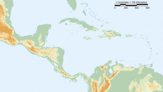
Physical map
Central America is a tropical isthmus through which North America and South America are connected. It is a mainly mountainous region, as well as steep, in which several mountain levels coexist, linked, in turn, to the North American and South American structures.
Likewise, this region of the American continent is dominated by geological systems in which there is one of the largest volcanic axes on the planet known as Central American volcanic arc; Thus, in the interior it is estimated that there are up to 60 volcanoes, most of them extinct, while on the Pacific coast there are more than 31 active volcanoes.
Some of the most important volcanoes in Central America are: Arenal Volcano (Costa Rica), Irazú (Costa Rica), Cerro Verde (El Salvador), San Miguel Volcano (El Salvador), San Vicente Volcano (El Salvador), Volcán from Atitlán (Guatemala), Chicabal Volcano (Guatemala), San Pedro Volcano (Guatemala) and Concepción Volcano (Nicaragua).
Furthermore, the Earth's crust of Central America is considered especially unstable as it lies on the western edge of the Caribbean tectonic plate, which is moving in a southeast direction.
In the northern part, on the other hand, a sedimentary terrain based on sandstone and limestone predominates, as well as a zone of fractures that extends towards the southeast, giving rise to the lakes of Central America.
Hydrographic map
Central American rivers are characterized by being short (because of the isthmic geography that we talked about in the previous section) and because it corresponds mainly to the Atlantic slope. In Panama is where the greatest influx of rivers is observed, due to the proximity to the oceans that surround this region of the American continent.
In general, the rivers of Central America fulfill several functions, among which is that of making border, as it happens with the Segovia and Coco rivers, located between Honduras and Nicaragua.
The longest rivers in Central America flow into the Caribbean Sea, while the rest (the shortest and most mighty) flow into the Pacific Ocean. The longest river in Central America is the Coco River, belonging to Nicaragua and Honduras, with a length of 680 km.
The most important rivers in Central America are those mentioned below:
| Name | Nacimiento | River mouth |
| Usumacinta | Quiche (Guatemala) | Gulf of Mexico |
| Lempa River | Chiquimula (Guatemala) | Usulután and San Vicente (El Salvador) |
| Ulua | Sierra Opatoro (Honduras) | Gulf of Honduras |
| Motagua River | Quiche (Guatemala) | Border between Honduras and Guatemala |
| Coco River | Border between Honduras and Nicaragua | Caribbean Sea |
As for lagos, Central America has a large number, most of which are born from an extinct volcano, so that, in reality, they are crater lakes. Here are the most important lakes in Central America:
- Belize: Laguna Cuatro Millas and Laguna del Río Nuevo.
- Costa Rica: Lake Botos, Lake Arenal and Laguna Diego de la Haya.
- El Salvador: Güija Lake, Ilopango Lake, Coatepeque Lake, Apaneca Green Lagoon, Olomega Lagoon and Suchitlán Lake.
- Guatemala: Lake Atitlán, Lake Amatitlán, Lake Izabal, Laguna de Chicabal and Lake Petén Itzá.
- Honduras: Yojoa lake.
- Nicaragua: Lake Cocibolca, Lake Managua or Xolotlán, Laguna de Apoyo Nature Reserve and Laguna de Apoyeque.
- Panama: Gatún Lake.
Panamerican's highway
The pan-american highway, Pan-American Route Or, simply, Panamericana consists of a road system through which the northern hemisphere of the American continent joins with the southern hemisphere, specifically, it goes from Alaska to Patagonia. In total, its length reaches 48.000 km, making it the longest road in the world.
It is worth mentioning that, as it passes through Costa Rica, the Pan-American Route is renamed Interamerican Highway and it is divided into the North Inter-American Highway and the South Inter-American Highway, depending on the direction in which it is driven, that is, to the north or south of San José (Costa Rica).
Thus, in its passage through Central America, the Panamericana crosses Guatemala, El Salvador, Honduras, Nicaragua, Costa Rica and Panama. Below we mention the areas through which it passes in each of these countries:
| Country | Ruta |
| Guatemala | San Marcos, Quetzaltenango, Totonicapán, Sololá, Quiché, Chimaltenango, Sacatepéquez, Guatemala, Santa Rosa and Jutiapa |
| El Salvador | Santa Ana, La Libertad, San Salvador, Cuscatlán, San Vicente, Usulután, San Miguel, La Unión, Santa Tecla and Cojutepeque |
| Honduras | Choluteca, Nueva Ocotepeque, Santa Rosa de Copán, San Pedro Sula, Siguatepeque, Comayagua, Tegucigalpa, Danlí, El Paraíso, Toncontin Airport, Nacaome, San Lorenzo, Choluteca, Frontera La Fraternidad and Frontera El Guasaule. |
| Nicaragua | Madriz, Estelí, Matagalpta, Managua, El Espino, Somoto, Carazo, Granada, Rivas, Jinotepe and Peñas Blancas. |
| Costa Rica | Guanacaste, Puntarenas, Alajuela, Heredia and San José (North Inter-American Highway). San José, Cartago and Puntarenas (South Inter-American Highway). |
| Panama | Border of Paso Canoas, Chiriquí, Veraguas, Population of Pacora and Darién. |
