
Cuba is an archipelago and country in the Caribbean Sea that thousands of people visit each year. Before traveling to it, it is important to know some basic aspects and know the location of each town. In this article, we show you different updated maps that could be of great help to you.
Below you have an index with all the points that we are going to deal with in this article.
Article Index
- 1.
- 2.
- 3.
- 4.
Touristic map
Cuba is a country that more and more tourists visit due to its interesting culture, historical buildings, the charm of the cities and the joy of its inhabitants.
Before visiting the island, it is important to know where each destination is located and the main services for tourists. Therefore, the following image is quite useful:
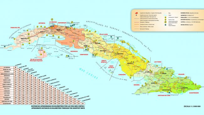
On the map we can see, among other things, the location of the points of tourist information, ports and airports. In addition, we find the distance between the main cities.
Political map
The political division of Cuba at present has been in force since 1976. However, in 2010 there was a change, as the former province of Havana was divided into Artemisa and Maybeque.
Therefore, today we find 15 provinces and a special municipality: Isla de la Juventud. This is the name of the provinces written in alphabetical order:
- Sagebrush
- Camaguey
- Ciego de Avila
- Casas Particulares Cienfuegos
- Granma
- Guantánamo
- Holguin
- Havana
- Casas Particulares Las Tunas
- Matanzas
- Mayabeque
- Pinewood of the river
- Sancti Spiritus
- Casa Particular in Santiago de Cuba
- Villa Clara
In this map you can see the location of each of them and their capital, which in most cases has the same name as the province to which they belong:
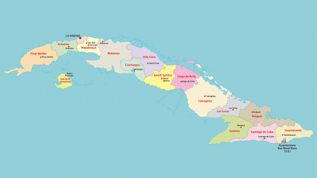
Likewise, within these provinces we find a total of 167 municipalities. Apart from the capitals, among the most populated are Arroyo Naranjo, Contramaestre and Boyeros. Here we find the most outstanding ones:
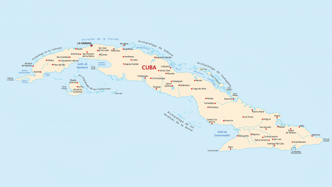
Physical map
Cuba has a total area of 109.884 km², making it the largest country in the Antilles. It consists of an archipelago with a main island surrounded by more than a thousand keys or small islands. In this silent physical map extracted from a satellite image you can see what the relief of the country is like:

Cuba has 5.746 km of coastline and around 289 beaches. It has flat areas and large mountain systems. The most prominent mountain ranges are:
- Guamuhaya Massif
- Guanicanico mountain range
- Sierra maestra
The highest point is Pico Turquino, which is 1.974 meters above sea level. The island's rivers are quite short. The longest is the Cauto River, which is 343 km long.
Other maps
One of the most comfortable ways to get around the island is by car. Therefore, it is vitally important to know the location of the roads. In this map you can see where the main roads of the country pass through:

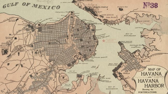
On the other hand, the cities of the country have been changing over the years. In this old map we can see what Havana was like in 1898. One of the areas that have been best preserved and which is one of the main attractions of the city is Old Havana, the oldest part.
This article has been shared 34 times. We have spent many hours collecting this information. If you liked it, share it, please:

