
London It is the largest city with the largest urban area on the entire island of Great Britain and Europe. Currently, it is estimated that 8,63 million inhabitants reside and its metropolitan area is divided into a total of 33 districts that are shown in the following sections together with maps of the airports, the subway and the bus lines.
Below you have an index with all the points that we are going to deal with in this article.
Article Index
- 1.
- 2.
- 2.1.
- 2.2.
- 2.3.
- 2.4.
- 2.5.
- 3.
- 4.
- 5.
- 6.
- 7.
Location in Europe and the world
As we said, London is located in England (United Kingdom), a country that is northwest of the European continent. The country, in turn, is part of the island of Great Britain, northeast of the Republic of Ireland. In the following map you can see exactly where the country is in relation to the rest of the world.

On a hydrographic level, the United Kingdom is surrounded by the Atlantic Ocean, the North Sea to the east and the English Channel (in English, EnglishChannel) to the south. For its part, british capital It is located in the south of the island of Great Britain, next to the River Thames, which runs through the city.
El Thames RiverSpecifically, it starts near Kemble (Gloucestershire, England) and crosses the cities of Oxford, Wallingford, Reading, Henley-on-Thames, Marlow, Maidenhead, Windsor, Eton and, finally, London. In total, its length reaches almost 350 km until its mouth in the English Channel. It is also a navigable river that connects London with the sea and with the country's inland canal network, including the Bristol Channel.

Airports
London has a total of 4 airports: Gatwick, Luton, Stansted and Heathrow. In addition, it also has the so-called London City Airport. We show you the maps of all of them in the following sections.
London Heathrow Airport
El London Heathrow Airport (IATA code: LHR), known simply as Heathrow, is the UK's main airport given its high annual traffic rate and the number of connections it offers. For example, in 2003 it received more international traffic than any other airport in the world.
Located 24 miles west of London, it connects to 160 destinations around the world via almost 100 international airlines. In addition to the 4 terminals it has, it is currently in the process of expansion and will have a total of 5 terminals.
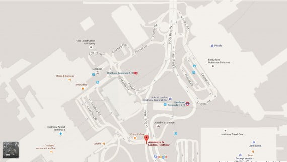
As can be seen in the previous map, while terminals 1, 2 and 3 are connected to each other, terminal 4 is located to the south of the airport and connects with Heathrow Express, the express train between Heathrow and London.
London Gatwick Airport
El London Gatwick Airport o London Gatwick Airport It is located in Crawley, West Sussex, about 5 miles north of the city center. From London, it can be reached by traveling the distance of 46 km along the M23 motorway heading south. From Brighton, the airport is located 40 km to the north.
Given the restrictions that the airlines of charter flights to operate at Heathrow, most are based in Gatwick. And the same happens with many transoceanic flights to and from the United States, due to the restrictions on flights of these characteristics in force at Heathrow.

London Stansted Airport
El London Stansted Airport (IATA code: STN), better known simply as Stansted, is found in Essex, 50 km from the city center, close to the M11 motorway that connects London with Cambridge.

Although it currently has a runway of more than 3.000 m, an extension is planned in which up to three more runways will be added. The main low cost airlines from Europe, such as Ryanair, the easy family of brands., Air Berlin or Germanwings, among others.
London Luton Airport
El London Luton Airport (IATA code: LTN), formerly called Luton International Airport, is located about 48 km northwest of central London, specifically in Luton, Bedfordshire. It is easily accessible by car through the M1 motorway from London. Luton is the fourth largest airport in the London metropolitan area after Heathrow, Gatwick and Stansted.

London City Airport
London City Airport or London City Airport (IATA code: LCY) was designed for takeoffs and landings in a short space, that is, on a single runway.
Compared to the other four, it is ranked number 5 in terms of traffic levels, since its main purpose is to provide quick access to the City of London, the main financial district of the city.

Conventional airlines such as Air France, Alitalia, British Airways, Iberia, EuroManx, KLM, Lufthansa, Luxair, Scandinavian Airlines, Scot Airways, Swiss and VLM Airlines are those that operate at London-City airport. The exact coordinates of the airport are 51.504837, 0.049509 and the address is as follows: Hartmann Rd, London E16, 2PX, UK.
Political division and districts
As we've already mentioned, London is a huge urban area. For this reason, since 2004 the city is divided into a series of sub-regions called North, East, West, Central and South. In addition, each of them is subdivided into municipalities or boroughs English.
Each of these sub-regions are the ones used when preparing postal codes, and the same happens in the rest of British cities. Thus, for example, when the letter W appears in a postal code, it means that the address is in the western subregion of the city. And the same abbreviations are used for each subregion: WC for Wis CITY, N for North, NW for North Wis, S for Souch, etc. If you want to know more about the postal service and the postal codes of the country, we advise you to read the article The Post Office in the United Kingdom.

The names of the different districts, such as Mayfair, Wembley, Whitechapel or Bloomsbury are, in fact, a series of informal designations that were used to remember the names of the different towns absorbed after the growth of the great metropolis. However, it should be mentioned that these administrative units do not have official limits.
London currently has 32 municipalities to which must be added the old City, currently converted into the main financial district of the city. Therefore, London is made up of a total of 33 districts distributed among its different subregions. In the following documentary a detailed review of the situation of the city of London today:
https://www.youtube.com/watch?v=sON6T9NNdwI
Subway lines
El London subway has a network in which there are in total 11 lines, which makes it one of the most extensive networks on the planet. This is very convenient for both locals and tourists, since it can be said that wherever you are you will have a metro stop very close. Thanks to this, moving around London by public transport is the most recommended option.

In addition, as in the underground networks of other cities, London is divided into 9 concentric zones. All of them start their route in the historic center of the city and from there they reach different points of the same. Luckily for tourists, it must be said that most of London's tourist attractions are located in zones 1 and 2, so moving from one to another is even easier. The remaining areas cover the surrounding area and the outskirts of London.
Bus network
The famous london red buses Two-story buildings are a nice way to get around the city, but not the most comfortable and fastest way to do it, especially when the journey is long distance. As we have explained in the previous section, the most advisable for this is the metro or underground, name given in English.
Even so, the network of london buses It is one of the largest in the world. It currently has about 400 bus lines and more than 15.000 stops spread throughout the city. The main disadvantage of such extensive public transport networks is that getting their bearings is somewhat complex, even for the native inhabitants of the city.
Although on the map below you can see the main bus routes through the center of London pointing out the main tourist attractions, if you want a detailed map of the London bus network we advise you to click on this link, which will take you to the official website.

Train Stations
The main train stations in London are a total of 9: Paddington, Marylebone, Euston, St Pancras. Kings Cross, Liverpool Street, Victoria, Waterloo and Charing X.
Thanks to them, moving by train within the country is relatively simple, since they offer practically any connection to anywhere, whether within England or outside of it, that is, in Scotland or Wales.
Below is a table that shows each of the stations along with the cities that can be reached and the possible connections:
| Station | Destination cities | Connections (if any) |
| Paddington | Oxford, Bristol South Wales, Bath, Exeter and Playmouth. | In Exeter bound for Southampton, Portsmouth and Brighton. |
| Marylebone | Warwick and Birmingham. | In Birmingham to North Wales, Liverpool, Manchester and Glasgow (Scotland). |
| Euston | Birmingham. | In Birmingham to Warwick and Marylebone Station or to North Wales, Liverpool, Manchester and Glasgow (Scotland). |
| st pancras | Leicester, Derby / Nottingham, Sheffield, Leeds, Paris-Brussels and Dover. | In Dover with Charing X Station and Victoria Station. |
| Kings Cross | York, Newcastle and Edinburgh (Scotland). | None |
| Liverpool Street | Cambridge and Norwich. | None |
| Charing X | Dover | From Dover it connects to Victoria and Waterloo stations. It also goes as far as Brighton and there it connects with destinations that can be accessed from Victoria. In Exeter it connects with the destinations of Paddington station. |
| Victoria and Waterloo | Birghton, Portsmouth, Southampton and Exeter. | In Exeter bound for Playmouth, Bath, Bristol South Wales and Paddington Station. |
Geography
England is one of the four nations that make up the United Kingdom and is located in the northern third of the island of Great Britain, northwest of Continental Europe and surrounded by almost 800 small islands including the Isle of Wight. In its totality, the territorial extension of England covers 129.720 km², with a population of 51.446.000.

At present, the expansion of the London urban area has been impeded by the Metropolitan Green Belt (Green Belt in English), which is the undeveloped area of the London metropolitan area. The Green Belt covers almost the entire territory of Surrey, eastern Berkshire, central and southern Hertfordshire, southern Buckinghamshire, southern Bedfordshire, western Kent, and southwest Essex. Furthermore, inner London is often spoken of for certain purposes (Inner london) and outer London (Outer London).
Area Inner London includes the following municipalities:
- Camden
- Greenwich
- H
- Hammersmith and Fulham
- Islington
- Kensington and Chelsea
- Lambeth
- Lewisham
- Southwark
- Tower Hamlets
- Wandsworth
- Westminster

For its part, London Exterior is the outer part of Greater London that surrounds Inner London and is composed of the municipalities of:
- Barking and Dagenham
- Barnet
- Bexley
- Brent
- Bromley
- Croydon
- Ealing
- Enfield
- Haringey
- Harrow
- Havering
- Hillingdon
- Hounslow
- Kingston upon Thames
- Merton
- Newham
- Redbridge
- Richmond upon Thames
- Sutton
- Waltham Forest

This article has been shared 83 times. We have spent many hours collecting this information. If you liked it, share it, please:

