Morocco Maps
Morocco is a country whose culture and heritage attract more and more tourists. Before traveling to this territory, it is important to know it in detail. In this article, we provide you with several complete maps to help you plan your visit.
Below you have an index with all the points that we are going to deal with in this article.
Table of Contents
- 1.
- 2.
- 3.
- 4.
Political map
Morocco is a country located in North Africa whose capital is Rabat. However, the most populous city is Casablanca, which has approximately 3,36 million inhabitants.
On this map of Africa you can see the location of Morocco (named as morocco, as it is in English) and its neighboring countries, as well as nearby archipelagos such as Madeira and the Canary Islands:


Regarding the political division of Morocco, the country is made up of twelve administrative regions. In this table you will find the name and capital of each one of them:
| Region | Capital |
| Tangier-Tetouan-Al Hoceima | Tangier |
| The Oriental | Oujda |
| Fez-Meknes | Fez |
| Rabat-Sale-Kenitra | Rabat |
| Beni Mellal-Jenifra | Beni Melal |
| Casablanca-settat | Casablanca |
| Marrakech-Safi | Marrakech |
| Draa-Tafilalet | Errachidia |
| Souss-massa | Agadir |
| Guelmim-oued noun | guelmim |
| Laayoune-Saguia el-Hamra | El Aaiún |
| Dakhla-Oued Ed Dahab | Dakhla |
In the following map we find the location of the most important provinces and cities in the country:

It should be noted that Morocco includes the territory of Western Sahara as its own. However, the United Nations (UN) does not recognize that this area corresponds to Morocco.
Geographic map
The highest peak in Morocco is tubqal, with 4.162 meters above sea level In terms of relief, it is formed by four main mountain ranges:
- Rif
- Middle Atlas
- Great atlas
- Anti Atlas
Besides these, in the country there are also areas of great plains and plateaus. In this silent physical map you can see what the relief is like in detail:

As for the rivers, some flow into the Mediterranean Sea and others into the Atlantic Ocean. Among the most important we find the Draa, 1.100 km long, the Muluya (520 km) and the Sebú (496 km).

If you are curious to know what Morocco looks like from space, with this satellite image you can get an idea. The territory that this country occupies is marked in blue on it:

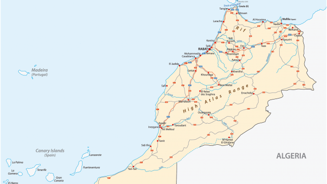
Road map
Although in the past the state of the roads in Morocco was not optimal, they are increasingly of higher quality, so there is no problem in traveling the country by car or motorhome.
In total there are eight in the country motorways, so Morocco has the second largest network in Africa, only behind South Africa. In this map we find the main roads of the territory:
Touristic map
Each area of Morocco has a special attraction for tourists. A unique part is the Sahara desert. If you want to know more about it, we recommend you visit the following article: 15 surprising curiosities about the Sahara desert.
Also, each city has a different charm. In Fez The tanneries stand out, made up of vats full of bleaches and colored dyes. In them, workers have been treating leather with the same technique since the Middle Ages.

On the other hand, in Marrakech the good state of conservation of its historic center and the walls is striking. The most popular square is Jemaa El-Fna, busy throughout the day.