
Portugal is part of the Iberian Peninsula and, therefore, is a European country. It is divided into 18 districts and, in addition, it has two autonomous archipelagos: Madeira and Azores. In total, the area it occupies reaches 92 km² and its coastline measures 391 km in length.
Below you have an index with all the points that we are going to deal with in this article.
Article Index
- 1.
- 1.1.
- 1.2.
- 1.3.
- 2.
- 3.
- 3.1.
- 3.2.
- 3.3.
- 4.
- 5.
- 5.1.
- 5.2.
Political map
The political division of Portugal is made up of a total of 18 districtsLisbon being the one with the largest territorial area and, consequently, the largest number of inhabitants.
These districts are:
- Lisbon
- Leiria
- Santarém
- Setúbal
- Beja
- Faro
- Évora
- Portalegre
- Castelo Branco
- Guarda
- Coimbra
- Aveiro
- Viseu
- Braganza
- Vila Real
- Porto
- Braga
- Viana do Castelo
In the sections shown below, we have divided the political map of Portugal into three parts: the north, the center and the south. In this way, it will be easier to view each district, as well as its cities.
North Zone
According to the map below, the northern part of Portugal covers a total of nine districts: Viana do Castelo, Braga, Vila Real, Bragança (Braganza), Porto (Oporto), Aveiro, Viseu Guarda and Coimbra.
Of all of them, the city with the highest number of inhabitants is Porto (Oporto in Portuguese), while the largest in terms of territorial extension is Bragança (Bragança in Portuguese).
In the following table, we show you the territorial extension of each one together with the number of inhabitants and the corresponding cities:
| District | Residents | Territorial extension (km²) | Cities |
| Viana do Castelo | 206.661 | 2.255 | Viana do Castelo and Valença |
| Braga | 848.165 | 2.673 | Braga, Guimarães, Barcelos, Vila Nova de Famalicão, Fafe, Esposende and Vizela |
| Vila Real | 206.661 | 4.328 | Vila Real, Chaves, Peso da Régua and Valpaços |
| Bragança or Braganza | 136.252 | 6.608 | Bragança, Miranda do Douro, Mirandela and Macedo de Cavaleiros |
| Porto or Porto | 1.817.119 | 2.395 | Oporto, Penafiel, Póvoa de Varzim, Vila Nova de Gaia, Matosinhos, Santo Tirso, Amarante, Maia, Vila do Conde, Ermesinde, Felgueiras, Valongo, Gondomar, Paredes, Marco de Canaveses, Paços de Ferreira, Trofa, Rio Tinto, Lixa , Freamunde, São Mamede de Infesta, Gandra, São Salvador de Lordelo, Rebordosa, Valbom, Alfena and Senhora da Hora |
| Aveiro | 714.218 | 2.808 | Aveiro, Espinho, São João da Madeira, Oliveira de Azeméis, Ovar, Santa Maria da Feira, Águeda, Ílhavo, Esmoriz, Vale de Cambra, Fiães, Gafanha da Nazaré, Lourosa, Mealhada, Oliveira do Bairro, Estarreja, Anadia and Albergaria- a-Velha |
| Viseu Guarda | 377.629 | 5.007 | Viseu, Lamego, Tondela, Santa Comba Dão, Mangualde, Tarouca and São Pedro do Sul |
| Coimbra | 429.987 | 3.947 | Coimbra, Figueira da Foz, Cantanhede and Oliveira do Hospital |

Downtown area
On the map, you can see the area that corresponds to the center of Portugal in administrative terms. Thus, we include here the following six districts: Castelo Branco, Leiria, Santarém, Portalegre, Lisbon and Évora.
Lisbon is the capital of Portugal and the most touristy of all, as well as the one with the greatest number of inhabitants, as can be seen in the figures shown in the following table:
| District | Residents | Territorial extension (km²) | Cities |
| Castelo Branco | 196.262 | 6.675 | Castelo Branco, Covilhã and Fundão |
| Leiria | 470.985 | 3.517 | Leiria, Caldas da Rainha, Peniche, Marinha Grande, Pombal and Alcobaça |
| Santarém | 453.633 | 6.747 | Tomar, Santarém, Abrantes, Rio Maior, Torres Novas, Almeirim, Entroncamento, Ourém, Cartaxo, Fátima and Samora Correia |
| Portalegre | 118.448 | 6.065 | Elvas, Portalegre and Ponte de Sor |
| Lisbon | 2.250.382 | 2.761 | Lisbon, Torres Vedras, Amadora, Vila Franca de Xira, Alverca do Ribatejo, Loures, Odivelas, Queluz, Sacavém, Póvoa de Santa Iria and Agualva-Cacém |
| Évora | 166.706 | 7.393 | Évora, Estremoz, Montemor-o-Novo, Vendas Novas, Reguengos de Monsaraz and Borba |

Zona sur
Finally, in the southern part of Portugal we include three districts: Setúbal, Beja and Faro. The first, Setúbal, is the one with the highest rate of population density, although, however, it is not the most extensive.
These data can be seen in detail in the following table:
| District | Residents | Territorial extension (km²) | Cities |
| Setúbal | 851.232 | 5.064 | Setúbal, Almada, Barreiro, Montijo, Santiago do Cacém, Amora, Seixal, Alcácer do Sal, Sines, Vila Nova de Santo André and Costa da Caparica |
| Beja | 152.728 | 10.225 | Beja, Moura and Serpa |
| Faro | 451.005 | 4.960 | Silves, Faro, Lagos, Portimão, Olhão da Restauração, Albufeira, Loulé, Vila Real de Santo António, Quarteira and Lagoa |

Physical map
Located in southwestern Europe, mainland Portugal encompasses 91.951 km², of which a large part corresponds to the Atlantic coast of the Iberian Peninsula and the rest belongs to the two autonomous archipelagos belonging to the Republic of Portugal: Madeira and Azores (440 km² of maritime zone in total).
Since Portugal is located on the Iberian Peninsula, the only border country is Spain, with which it borders to the east and north. To the south and west, it borders the Atlantic Ocean along its 1.783 km of coastline.
As can be seen on the map, the northern territory is especially mountainous in the interior areas, which is very favorable for the development of the primary sector (agriculture). This type of mountainous landscape is known as flat.
As for the southern area (up to the Algarve), the terrain is made up of plains interspersed with some low-lying mountains. Ultimately, the highest point is the Peak Mountain (Pico Mountain, Pico Bridge o Serra do Pico), located in the Azores, whose summit is at an altitude of 2.351 m and is actually active volcano which came into operation for the last time in the XNUMXth century.
Other Azores islands have also had recent volcanic activity, such as the Volcano of the Capelinhos, located on the island of Faial, which last erupted in 1957.
In contrast, the archipelago of Madeira is located on the African plate, making it the most stable region in Portugal in terms of risk of earthquakes. The last volcanic eruption in Madeira took place 6.000 years ago.
As for the coast of Portugal, it includes, apart from the 1.230 km of continental territory, the 667 km of the Azores and the 250 km of Madeira, the Wild Islands (between the Canary Islands and Madeira), the Desertas Islands (located southeast of Madeira) and the island of Porto Santo (northeast of Madeira).
Portuguese beaches are characterized by their great variety of sandy beaches and Cliffs.

Highway map
Portugal's road system is divided into highways with exclusively electronic toll collection system (without manual toll), highways and SCUT sections (free or free highways) and highways with conventional toll (manual booths, automatic payment machines, automatic card / money payment lanes and greenway lane).
As for the highways and SCUT sections, they work with the gantry / arch system, that is, electronic toll collection, so only electronic payment is allowed. This means that the toll collection is automatic, that is, the system detects each car when it circulates under the toll gates.
The foreign Those who circulate on these routes have two electronic payment options: on the one hand, pay with an electronic device or adhere to the payment methods for registration recognition.
On the maps shown in the following sections, you can get an idea of which are the main highways in Portugal, as well as which are electronic toll, which are free and which continue to have the conventional toll system.

North Zone
The following list shows the electronic toll roads that pass through the north of Portugal:
- North Coast Concession: A28 Viana (Darque) -A41
- Greater Porto: A41 (A28-A42) + A42 (A41-A11) + A4 Custòias-A3
- Prata Coast: A29 Miramar-Estarreja + A17 (Litoral Centro) Mira-Aveiro Stadium + A25 (Beiras Litoral e Alta) Esgueira-Albergaria (A1)
- Interior North: A24 Vila Verde de Raia-Viseu
- Beiras Litoral and Alta: A25 Vilar Formoso-Aveiro
And the following list lists the highways and SCUT sections (free) from the north of the country:
- A28: Vilar de Mouros (Caminha) -Viana
- A28 highway: A41 (km 11) -Oporto (km 0)
- A27: Ponte de Lima (A3) -Viana (A28)
- IP4: Amarante-Spain (except variant of Bragança)
- A24: Spain-Vila Verde de Raia (EN103) / R506
- A25: Spain-Vilar Formoso (EN-332)
- A20: internal regional circular Porto (CRIP)
- A30: Sacavém-Santa Iria de Azóia
- A43: Porto Aguiar de Sousa
- A44: A29-A20
Finally, these are the roads in the north of Portugal that maintain the system of conventional toll:
- A3: Valença-Porto
- A4: from the A3 to Amarante
- A7: Vila de Conde-Vila Pouca de Aguiar
- A11: Barcelos-Penafiel
- A14: Figueira da Foz-Coimbra
- A17: Mira-Leiria

Downtown area
These are the roads that benefit from the electronic toll or electronic tolls that pass through the central area of Portugal:
- Pinhal Interior Concession: A13 / IC3 Atalaia (A23) -Condeixa (N2 / IC2)
- Subconcession AE Transmontana (A4): variant of Bragança
- West Coast Concession: A19 (São Jorge-Azoia) + A8 (variant of Leiria)
- Interior edge: A23 Guarda-Torres Novas
- Lower Yew: A33 (Belverde-Coina)
Instead, the following roads are free circulation or SCUT:
- A29: Miramar (A44, km 47) -A20 (km 53)
- A31: Coimbra variant
- A34: Pombal-A1
- A36: Interior Lisbon regional circular
- A37: Radial of Sintra
- A39: Barreiro fast track
- A40: Radial Odivelas
Finally, the network of highways that maintain the concenvional toll The largest of Portugal is in this area, since it is where Lisbon, the country's capital, is located and, therefore, there are more traditional access roads. These are the roads with a conventional toll system in central Portugal:
- A1: Porto-Lisbon
- A5: Lisbon-Cascais
- A6: Elvas-Lisbon
- A8: Lisbon-Leiria (south)
- A9: Lisbon outer ring road
- A10: Bucelas-Benavente
- A12: Lisbon- Setúbal
- A13: Almeirim- Marateca
- A15: Obidos-Santarem
- A16: Alcabideche-Circular Regional Interior of Lisbon (CRIL)
- A21: Ericeira-A8

Zona sur
The southern part of Portugal, encompassing only three districts (Setúbal, Beja and Faro) as mentioned above, only two main highways are located, each one of one type.
On the one hand, the stretch Infante of Sagres (Autoestrada do Algarve): A22 Monte Gordo-Lagos, which is an electronic toll; and, on the other hand, the road A22 Spain-Exit N125 / Montegordo, whose circulation is free or of the SCUT type (sem custo for or user).
As for the carts with a conventional toll system, in the southern zone the user can circulate on the A2 in its Albufeira-Lisbon section.

Hydrographic map
El tagus river (Tejo in Portuguese) is the longest river in the entire Iberian Peninsula. It is born in the Sierra de Albarracín, Teruel (autonomous community of Aragon, Spain), specifically in the so-called Universal Mountains, and travels through Spain in a westerly direction to Lisbon, where it finally empties into the Atlantic Ocean after traveling 1.007 km. The Tagus River divides Portugal into two halves.
Other equally important rivers that originate in Spain are the Duero, Guadiana and My no (Douro, Guadiana y Minho respectively in Portuguese).
The Duero River is born in Fuentes del Duero, Duruelo de la Sierra, Soria, and flows into Oporto. The Guadiana meanwhile runs through the Submeseta Sur to Badajoz (Extremadura, Spain), where it heads south until it empties into the Atlantic Ocean.
Finally, the Miño River runs almost entirely through Galicia and forms a natural border between Spain and Portugal in Pontevedra until its mouth once more in the Atlantic.
However, Portugal also has a network of rivers that have their entire course in Portuguese territory, such as the vogue, Mondego, Sado and DigThe latter with its source in the Sierra de Larouco and which runs for 135 km until its mouth in Esposende after passing through Braga and Barcelos.
It is one of the largest rivers in Portugal, so the water resources it stores correspond to almost 30% of the country's total.
As for lagos of Portugal, it is worth mentioning that in Portuguese territory there are no large lakes. However, there are some of glacial origin in the interior of the country, such as the Comprida and the Escura, the latter located in the Sierra de la Estrela, and others belonging to the marshes of Albufeira, Aveiro, Braças, Óbidos and Candle.

Archipelagos and islands
In addition to the continental territory located on the Iberian Peninsula, Portugal has two autonomous archipelagos. Thus, on the one hand is Madeira, whose location is in Africa; on the other hand, the Azores, which are in the northern hemisphere of the Atlantic Ocean.
In the two sections shown below, we present both archipelagos together with a map of each one.
Azores
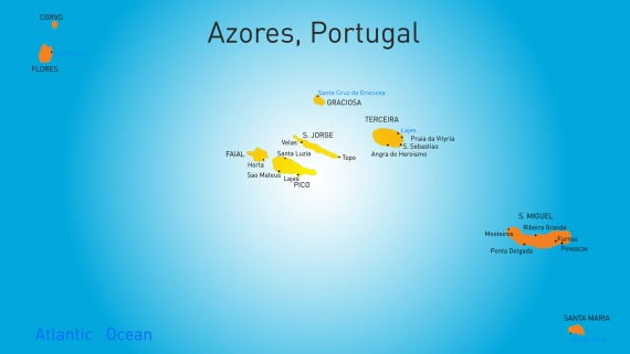
The Autonomous Region of the Azores or, simply, Azores is an autonomous archipelago belonging to Portugal that is made up of a total of nine islands located in the middle of the Atlantic Ocean about 1.400 km off the Lisbon coast, of which São Miguel it is the largest, with its 759 km².
The Azores are part of Macaronesian, a collective term that refers to the five archipelagos found in the North Atlantic (Azores, the Canary Islands, Cape Verde, the Wild Islands and Madeira). Like Madeira, they are considered an outermost region of the European Union (EU).
The total area occupied by the nine islands that make up the Azores is 2.333 km².
Actually, these islands are of volcanic origin, a fact that can be observed in the different volcanic cones and craters found in them, such as the Pico volcano, located on the homonymous island, which also constitutes the highest peak in Portugal.
It is considered as a active volcano, since its last eruption took place in 1957 on the island of Faial.
The nine islands that make up the Azores are those mentioned in the following table together with their corresponding municipalities:
| Isla | Municipalities | Territorial extension (km²) |
| Flores Island | Lajes das Flores and Santa Cruz das Flores | 143 |
| Corvo Island | village of crow | 17 |
| Terceira Island | Angra do Heroísmo and Praia da Vitória | 403 |
| Graciosa Island | Santa Cruz da Graciosa | 62 |
| São Jorge Island | Calheta and Candles | 246 |
| Pico Island | Lajes do Pico, São Roque do Pico and Madalena | 446 |
| Faial Island | Horta | 173 |
| Santa Maria Island | About Us | | 97 |
| São Miguel Island | Lagoa, Nordeste, Povoação, Ponta Delgada, Ribeira Grande and Vila Franca do Campo | 759 |
Madeira
The Autonomous Region of Madeira, better known as Madeira and adapted to Spanish as WoodAlthough this term is currently in disuse, it is an autonomous archipelago of Portugal that constitutes an outermost region of the EU.
The archipelago consists of two inhabited islands, Madeira and Porto Santo, as well as three uninhabited islands that are collectively known as Desertas Islands.

Madeira is popularly known as The Pearl of the Atlantic, since it is a leafy island formed by volcanic eruptions that took place thousands of years ago.
This mountainous territory offers multiple options for tourists, such as hiking through Pico Ruivo, the highest peak on the island at 1.800 m high. Its capital, Funchal, offers tourist attractions such as the XNUMXth century Sé Cathedral and the Museu da Quinta das Cruzes, among others.
As for the Porto Santo, is located 40 km from Madeira and stands out for its golden sand beaches. Its capital is Vila Baleira and it is where Christopher Columbus lived, so you can visit the Christopher Columbus Museum.
This article has been shared 52 times. We have spent many hours collecting this information. If you liked it, share it, please:


