
Ireland is an island whose territory belongs to two different countries: the Republic of Ireland and the United Kingdom. In this article we show you different maps of the area in which its political division and the name and location of the most important cities are reflected, among other aspects.
Below you have an index with all the points that we are going to deal with in this article.
Article Index
- 1.
- 2.
- 3.
- 4.
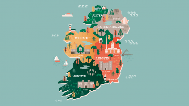
Political map
Ireland is a country belonging to the European Union that is located in the Pacific Ocean. This country is divided into four provinces: Leinster, with its capital in Dublin, Ulster (Belfats), Munster (Cork) and Connacht (Galway).
In the case of Ulster, a large part of the territory belongs to North Ireland, an area that is part of the United Kingdom. In the following image you can see the location of each province and its capital:

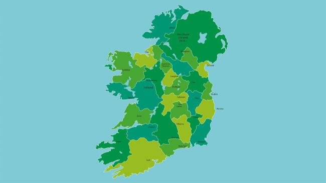
At the same time, this territory is divided into a total of 32 counties. The most populous is the county of Dublin, with about 1,3 million inhabitants living there. Here are the names of all the counties:
- To: Antrim, Armagh
- C: Carlow, Cavan, Clare, Cork
- D: Donegal, Down, Dublin
- F: Fermanagh
- G:Galway
- K: Kerry, Kildare
- L: Laois, Leitri, Londonderry, Longford, Louth
- M: Mayo, Meath, Monaghan
- Or: Offaly
- A: Roscommon
- S: Sligo
- T: Tipperary, Tyrone
- W: Waterford, Westmeath, Wexford, Wicklow
Physical map
The island of Ireland is the third largest in Europe, as it has an area of 84.421 km². 83% of this territory belongs to the Republic of Ireland and the remaining 27% to the United Kingdom.
Much of the relief is made up of large plains and low mountains. The highest peak is carrantuohill, which has an altitude of 1.041 meters above sea level. The main mountain ranges are the following:
- Donegal
- MacGillycuddy's Reeks
- mourne
- Wicklow

The coastline in the area is quite rugged and cliffs, as well as small peninsulas, are plentiful. As for the rivers, the longest is Shannon, with 386 km in length. Other notable rivers are the Blackwater, Bann and Barrow.
In Ireland we also find numerous lakes. Among them we find the lakes Lough Allen, Corrib, Lough Ree and Erne. The largest is Lake Neagh, which has an area of 392 km².

Road map
The roads in the Republic of Ireland are of good quality. The country has more than 1.000 km of highways and highways. If the road name begins with the letter M, (for example, M50), it is a motorway, while if it has the letter N it is a national road.
The M50 road is the motorway that runs around Dublin. This has an innovative system: the toll without barriers. Thanks to this, drivers do not have to stop to pay, but a camera photographs their license plate and must pay the corresponding amount online or by phone.

On the other hand, in the following map you can see the railway network of Ireland. The train connects the main cities, especially Dublin, although there are areas that are not so well connected.

Other maps
On this tourist map you can see drawn the main attractions and places of interest, both in Northern Ireland and the Republic of Ireland (an area that some people call southern ireland).
Also, people interested in history can see how both Ireland and Great Britain were conceived in the XVI century thanks to this map dating from 1564.

This article has been shared 24 times. We have spent many hours collecting this information. If you liked it, share it, please:
