
In Spain you can access practically any area by road. However, before driving, it is wise to consult a road map to decide which route to take. In this article, we show you some very useful national and regional maps.
Below you have an index with all the points that we are going to deal with in this article.
General map
The Spanish road network has more than 165.000 km spread throughout the country. Although the origin of the main ones is in MadridCurrently there are also transversal axes that do not pass through this city.
In the following map you can see the main roads Spain (red lines), as well as the railway line (black and white lines):

Of this entire network, around 15.000 km are motorways and dual carriageways, also known as high capacity roads. For this reason, Spain is one of the European countries with the highest number of kilometers of this type of road.
These are some of the most important roads in the country and the starting and ending towns:
- A1 North Highway: Madrid - Irún
- A2 Northeast Highway: Madrid - Border of France
- A3 East Highway: Madrid - Valencia
- A4 South Highway: Madrid - Cádiz.
- A5 Southwest Highway: Madrid - Portugal
- A6 Northwest Highway: Madrid - La Coruña
- A7 Mediterranean Highway: Barcelona - Algeciras
- A8 Cantabrian Highway: Galdácano - Baamonde
- AP9 Atlantic Highway: Ferrol - Portugal

Most of the roads in Spain are in good condition, especially the main ones, so you can drive on them without problem with any vehicle allowed.
Autonomous maps
Not all roads are competences of the State, but we also find the regional, provincial and municipal networks, which depend on the bodies of these territorial divisions.
One of the most complete networks is that of Catalonia, where we find highways, highways, national, regional and local roads. With this map you can get an idea of the distribution of the main ones:

In this case, the center from which the main networks start is Barcelona, the capital of the community, while the interior does not have such optimal communication.
Also, although the islands belonging to Spain are small, they have their own roads. These are the main means of transportation in them. In the case of Menorca, on the Balearic Islands, we find these roads:
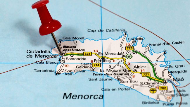
However, there are no motorways or highways here, so if you drive around the island, remember that the maximum speed allowed is lower than in other parts of the country.
Every year, the Ministry of Public Works publishes on paper the Official Road Map. This one provides a lot of information. It also includes a DVD. You can buy it by clicking this link.
Likewise, on the website of the DGT (General Traffic Directorate) you can consult updated information on the state of the roads. You can access through this link.
This article has been shared 31 times. We have spent many hours collecting this information. If you liked it, share it, please:

