Central America is based on the Caribbean plate, which makes it the owner of numerous lakes and short but mighty rivers, due to its isthmic geography. Among the most important lakes in Central America we highlight those mentioned below.
Below you have an index with all the points that we are going to deal with in this article.
Article Index
- 1.
- 1.1.
- 1.2.
- 2.
- 2.1.
- 2.2.
- 2.3.
- 3.
- 3.1.
- 3.2.
- 3.3.
- 3.4.
- 3.5.
- 3.6.
- 4.
- 4.1.
- 4.2.
- 4.3.
- 4.4.
- 4.5.
- 5.
- 5.1.
- 6.
- 6.1.
- 6.2.
- 6.3.
- 6.4.
- 6.5.
- 7.
- 7.1.
Belize
Belize is located in the extreme northwest of Central America, bordering Guatemala to the south and west and Mexico to the north, while at the same time caribbean coast from northern Central America. Although the total area of the country is 22.960 km², it has a large number of lagoons, keys and atolls along its coasts, which reduces the real land area to 21.400 km².
Four Mile Lagoon
The Four Mile Lagoon was discovered in 1765 by the English navigator James Cook, who described it in his day as a magnificent lagoon located in the southern part of the Deep River. In fact, the name of Four miles it is because this lagoon is four miles (six kilometers) from that river.
The fauna that lives in it is that of the Yucatan Peninsula; Thus, there are reptiles such as the swamp crocodile or the hawksbill turtle, birds such as the pink flamingo or the matraca, and mammals such as jaguars, pumas or tremors.

New River Lagoon
The Río Nuevo Lagoon is actually the source of the Río Nuevo and is located in the district of Orange walk, although it flows into the neighboring district of Corazol.
This lagoon is next to the famous Lamanai Mayan Ruins, whose name comes from the Yucatec Mayan language and literally means submerged crocodile.
Therefore, as its name indicates, in this lagoon there is the presence of swamp crocodiles, a species of reptile that can be found in practically all the lagoons of Belize. In addition to crocodiles, other species such as monkeys or wild birds can be found in the area.

Costa Rica
Costa Rica or Republic of Costa Rica is a Central American country that borders Panama to the southeast and Nicaragua to the north, and is surrounded by the Caribbean Sea and the Pacific Ocean.
El highly mountainous relief Costa Rica is largely made up of various volcanoes, many of which are active, as is the case of the Poás Volcano, in whose crater is the green-water Botos Lake.
Thus, it is common for many of the lakes in Costa Rica to have been formed in the crater of a volcano, as is also the case of the Barva Volcano, among others.
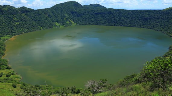
Botos Lake
Lake Botos is located in the Costa Rican Poás Volcano National Park, which covers an area that covers about 65 km².
As its name suggests, the main tourist attraction of this national park is the Poás Volcano, a active volcano which is currently considered one of the highest peaks in Costa Rica and is part of the Central Volcanic Mountain Range.
Lake Botos is actually the crater of the Poás Volcano, whose waters are green due to the large amount of sulfuric acid that contain.
This lake is surrounded by a cloud forest that is characterized by having a high concentration of surface fog. He was given the name of Botos in honor of the groups indigenous peoples of Central America that once inhabited this area.

Lake Arenal
Lake Arenal is the most important lake in Costa Rica by the extensive surface that it covers (30 km long and 5 km at its widest point). It is located on the banks of the Arenal Volcano, in the Arenal Volcano National Park. This national park is in the district of La Fortuna, in the province of Alajuela.
Lake Arenal is actually an artificial reservoir that was formed after the construction of a dam in 1979. The depth of its waters can reach 60 meters, although it is normal for it to reach about 30 meters.
It is currently one of the main points of hydroelectric production of the country, with a production level that exceeds 40%.
In tourist terms, the lake has become one of the most visited places due to the fact that it is possible to practice countless watersportssuch as kayaking, windsurfing or canoeing, as well as fishing activities.

Diego de la Haya Lagoon
Irazú It is an active stratovolcano that is located in the Central Volcanic Mountain Range and, as happened with the Poás Volcano and the Arenal Volcano, a national park has been established with its name.
Located in the province of Cartago, at its summit you can find various craters, of which the main one contains a small crater lagoon of green variable depth depending on the season and is known as Diego de la Haya Lagoon o Diego de la Haya crater.
When the temperatures are low and the fumaloric activity is minimal, this lagoon dries up, revealing a slightly humid or totally dry and rocky terrain.

El Salvador
El Salvador or Republic of El Salvador is a country with a warm-tropical climate that borders to the east and north with Honduras, to the west with Guatemala and to the southeast with the Gulf of Fonseca, and is surrounded to the south by the Pacific Ocean.
Although the country has the smallest territorial extension in Central America, there are several protected areas, among which the Volcanoes National Park, the Montecristo National Park and the El Boquerón National Park stand out; in all of them, you can find numerous active volcanos in whose crater there is a lake or lagoon.
The area of the coastal chain and border mountains, where the most important lakes in the country are located.
Güija Lake
Lake Güija is actually a border lake, since it is a shared area between Guatemala and El Salvador, although most of the territory corresponds to El Salvador. Specifically, it is located between the Salvadoran department of Santa Ana and the Guatemalan department of Jutiapa.
As with many of the lakes and lagoons of Central America, Lake Güija is located in a volcanic area, so that it is surrounded by the extinct volcanoes of San Diego, Mita and Cerro Quemado, in addition to having an islet and several islands, including the Teotipa Island (also called Tipa Island, Island of Las Penitas o Peñitas Islands).
From this island you can see the vast majority of species that this lake has, which stands out for being of an intense green color due to the abundant vegetation that grows there. As for the fauna, there are numerous lizards y snakes like boas or vipers.

Lake of ilopango
Lake Ilopango (El Salvador) is considered a national paradise where you can go quietly for a boat trip, sail or go fishing for mojarras, juilines and guapotes, among other species.
It is a lake of volcanic origin located in the city of San Salvador, specifically between the departments of La Paz, San Salvador and Cuscatlán. With an area of 72 km² and a depth of 230 m, it is the largest natural lake in the country.
The origin of this lake dates back to a volcanic eruption that took place in the 6th century AD, which swept away numerous Mayan populations. Currently, it has a level 100 in the volcanic explosion index, which means that it is an area with a high probability of becoming active every XNUMX years.
The last eruption of this underwater volcano took place in the period between 1879-1880 and resulted in the production of a lava dome inside the lake, which formed the famous Burnt Islands.

Lake Coatepeque
The Lake of Coatepeque is, like the Lake of Ilopango, a natural lake of volcanic origin which is located south of the city of Santa Ana, in El Salvador. In Nahuatl language, Coatepeque means hill of culebras.
This lake has an island known as Teopán o Cerro Island (possibly due to the earlier translation of the Nahuat language) and two small peninsulas or rock formations known as eyeglasses, in which the Pipil Indians had a temple, as well as a monolith in honor of the Goddess Itzqueye.
Although in some areas its waters are thermal because it is located on a crater, the waters of Lake Coatepeque are considered calm, which favors the practice of watersports, among which are sailing, water skiing, diving and swimming, among others.
All this, added to the excellent views of the Santa Ana Volcano and the green hill that can be enjoyed from the lake, make it one of the most touristic places in El Salvador and, for this reason, there are currently numerous hotels around.

Green Lagoon of Apaneca
The Green Lagoon of Apaneca receives this name because it is located 2,5 km from the municipality of Apaneca, in the Department of Ahuachapán (El Salvador) and belongs to the Apaneca-Ilamatepec Biosphere.
The name green lagoon is derived mainly from the color of its waters, due to the wide range of aquatic plants that grow in them, and also the fact that it is surrounded by abundant vegetation, especially pine and cypress forests, thanks to the pleasant climate that prevails in this area during most of the year.
The lake has two peaks, one almost 2.000 m above sea level and the other about 1.700 m, between which a crater of 0,5 km in diameter and approximately 50 m deep opens.
In addition, it is surrounded by a path that makes up the famous Flower Route, which can be explored on foot and where you can see fields of flowers (hence its name), pine trees and an area where you can rest and have a drink.

Olomega Lagoon
The Olomega Lagoon was declared Wetland of International Importance by the Ramsar Convention in 2010.
Located between the departments of San Miguel and La Unión, this lagoon is ranked number 3 in the wetlands of El Salvador, because it is the largest body of natural fresh water in the so-called Central Depression because since it is the Rio Grande de San Miguel the one that provides most of its flow, especially in times of rain.
The depth of its waters reaches an average of 3 meters and in its interior are the Olomega Island and the Olomeguita Island, as well as some isolated islets in the southeastern sector of the lagoon.
A significant number of migratory waterfowl they reside on its banks, such as white herons, pigs and pichiches, among other species.

Suchitlán Lake
Lake Suchitlán or Embalse del Cerrón Grande is a lake that belongs at the same time to four different departments located between the central zone and the northern zone of El Salvador. This reservoir was formed in 1976 after the construction of the Cerrón Grande Hydroelectric Plant, in the Lempa River.
Name Suchitlan is original from the Nahuat language and means flower place, due to the fact that a large number of aquatic plants even though it is an artificial lake. It is also the habitat of numerous species of birds and fish, which makes it a place of ecological interest.
The lake produces a high percentage of electrical energy and is of utmost importance for the country's fishing activity; For this reason, it has been declared the Cerrón Grande Wetland in order to preserve its flora and fauna, and promote sustainable development with the aim of maintaining it as one of the main tourist attractions in El Salvador and a source of life for thousands of fishermen and residents.
There is also the possibility of practicing sports such as kayak o take a ferry ride.

Guatemala
Guatemala, officially the Republic of Guatemala, is a country located in the extreme north-west of Central America. When it comes to its lakes, Guatemala has a total of 23 lakes, as well as more than 100 minor lagoons. Thus, about 950 km² of the total 108.000 km² that the country occupies is covered by the group of lakes, with Lake Izabal being the largest of all.
Lake of Atitlán
Lake Atitlán (from the Nahuatl language: between water) is a huge lake of volcanic origin located in the south of Guatemala and that many consider the most beautiful lake in the world due to its blue waters occluded in a caldera with practically vertical walls derived from the crater of the inactive volcano that is in its depths.
Guatemala is possibly the American country where the Mayans left the greatest legacy, a fact that can be seen reflected in the high percentage of the Guatemalan population that lives in the country today, many of which continue to inhabit the shores of Lake Atitlán.
Three large and symmetrical conical volcanoes emerge at one end of the lake: the San Pedro volcano, Atitlán volcano and Toliman volcano.
Regarding its depth, only approximate data on it have been provided ranging between 300-350 m depth. One of the main characteristics of Lake Atitlán is the famous Xocomil wind, which is a strong wind that usually occurs at noon and causes strong waves in its waters.
The meaning of the term xocomil es collect sinsTherefore, according to legend, this wind reaches the lake every day to collect the fish from those who inhabit its surroundings.

Lake Amatitlán
Lake Amatitlán is among the main lakes in Guatemala. Located 1.186 m above sea level and with an area of 15,2 km², it is located in Guatemala City, specifically in the municipality of Amatitlán, hence its name.
Its waters have an average depth of 15 m and a maximum of 32 m. This lake belongs to the Pacific watershed And the depression on which it rests is in the volcanic complex that form the Pacaya Volcano, the Fuego Volcano, the Acatenango Volcano and the Agua Volcano.
It has been shown by reading some ancient documents that at first this lake was known as Atescate Lake. It is also characterized by the presence of what is called saunas, that is, warm waters fed by the heat of the volcanoes that surround it.
One of the problems this lake faces is the contamination, since it feeds on the waters of the Villalobos River, one of the main sewage drains of domestic, industrial and agro-industrial origin.

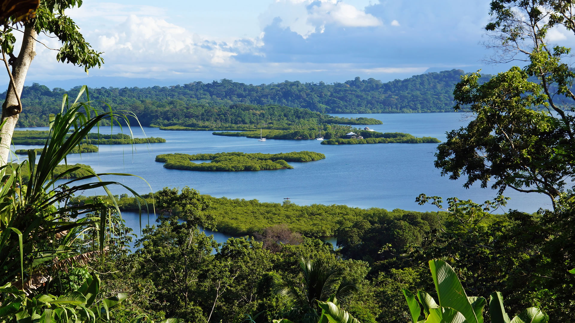
Izabal Lake
Lake Izabal, also known as Gulf Dulce, is located at the mouth of the Río Dulce, in the Department of Izabal, Guatemala. For its 45 km long and 20 km wide, it is the largest lake in Guatemala.
The lake makes a route during which it becomes a river in some sections until the town of Lívingston. The Golfo Dulce is located in a practically wild and sparsely populated area. Those who live near it in the tributary streams of the Rio Dulce move around the lake by boat.
Two main species can be found in the area: the sea cow and quetzal. Apart from these biotopes, other mammals can be found (spider monkeys, anteaters, coatis ...) and birds (herons, pelicans, and toucans), as well as fish (freshwater sharks, bass, snook, quixques ...), crustaceans (shrimp white, crabs, jutes ...) and reptiles (American crocodile).
From the municipality of Morales, you can take a boat to take a tour with a stop at the Tatín River, one of the main tributaries of the lake. In addition, you can visit the Castle of San Felipe de Lara, a fortress located at the mouth of the Río Dulce with this lake.

Chicabal Lagoon
The Chicabal Lagoon is a lagoon formed in the crater of the Chicabal Volcano and it is located in the Quetzaltenango division, Guatemala. This lake was considered by the Mayan population as a sacred lake and it was the center of the Mam worldview, which is why they built numerous altars on its shores.
According to legend, both the volcano and the lagoon are protected by the so-called nahuals, that is, representations of elements of nature that protect people from the moment they are born. Thus, Chicabal means in Mayan language sweet spirit water.
In addition, it is common for the surface of the waters of the Chicabal Lagoon to produce a thick fog that stays resting for most of the day. Even today, this lagoon is a sacred symbol for current Guatemalan indigenous people and, for this reason, bathing in its waters is prohibited.

Lake Petén Itzá
Lake Petén Itzá, also known as Guatemalan Petén, is a lake that is located in the Department of El Petén, in the north of Guatemala.
With its 99 km² and 160 m deep, it is considered the third largest lake in Guatemala, behind Lake Izabal and Lake Atitlán.
In addition, in one of its islets, known as Flores Island, the city of Flores is located, departmental head of El Petén and in which there are two important archaeological and tourist sites of Mayan origin: Tikal y Tayasal.
In the surroundings of the lake, in addition, there are several lodging options and places to have a drink, as well as a protected area where you can camp known as Cerro Cahui.

Honduras
Honduras, officially recognized as the Republic of Honduras, is a country located in Central America and is bordered to the north and east by the Caribbean Sea, to the southeast by Nicaragua, to the west by Guatemala and to the south by the Gulf of Fonseca and El Salvador.
The total extension of the country exceeds 112.000 km², of which almost 83% corresponds to basins of its hydrographic system, which is made up of nineteen river systems and more than thirty lagoons, most of them located in the north of the country. Of all of them, the only natural lagoon is Lake Yojoa, of volcanic origin. In addition to this lake, the Brus Lagoon, the Ébano Lagoon and the Criba Lagoon stand out.
Yojoa lake
The Lake of Yojoa or Lake of the Lizards It is the only lake of volcanic origin in Honduras and the largest in the country with a length of 16 km and a width of 6 km.
Its location is between the departments of Santa Bárbara, Cortés and Comayagua, and is 184 km from Tegucigalpa, capital of Honduras. The richness of this lake has meant that, in 2005, it was declared Wetland of World Interest by the UN, through the Ramsar Convention, as it is seen as an open door to research on wetlands.
Around the lake there are another 13 wetlands and various ecosystems, among which the limestone mountain of Santa Bárbara stands out, considered the largest mountain in Central America. Approximately, a total of 800 herbaceous species grow in this protected area, which translates into 10% of the total flora of Honduras. Similarly, a wide range of birds, mammals and reptiles have been identified within this habitat.
Regarding tourism, the lake offers multiple tourist attractions, from restaurants and hotels, to swimming pools and zoos, among which the following stand out: Joya Grande Zoo, Bogran Castle Ruins, Los Naranjos Eco-Archaeological Park, Taulabe Caves, etc.

Nicaragua
Nicaragua is a Central American country that borders Costa Rica to the south and Honduras to the north, and has coasts on both the Pacific Ocean and the Caribbean Sea. Nicaragua is considered as a country in which lakes and rivers abound, many of them located in a nature reserve.
Cocibolca Lake
Lake Cocibolca, better known as the Great Lake of Nicaragua, is the largest in Central America, the second largest in Latin America after Lake Maracaibo (Venezuela) and is ranked 25th worldwide.
Located in the city of Granada, it is a freshwater lake whose extension reaches almost 9.000 km² and in its interior there are more than 400 islets, 2 volcanoes and 3 main islands: that of Ometepe, considered one of the Seven Natural Wonders of the World, Zapatera and Solentiname.
One of its main characteristics is that it is the only lake in the world in which they live Sharks adapted to a freshwater ecosystem that enters and leaves it through the San Juan River.

Lake Managua or Xolotlán
Lake Managua or Xolotlán is located in the city of Managua, in the western part of Nicaragua, in the lowlands of the country. With an area of 1.049 km², it constitutes the second longest lake in Nicaragua after Lake Cocibolca, with which it is connected through the Tipitapa River.
On the shores of the lake is the Momotombo volcano and, to the northwest, the Island of Momotombito. The main tourist attraction are the boat rides that can be done along the lake, ranging from the municipality of San Francisco Libre to the Island of Love.

Masaya Lagoon
The Masaya lagoon is located at the base of the homonymous volcano. Given its proximity to the volcano, it is a crater lagoon whose structure is essentially volcanic. Although it is located in the Masaya region, hence its name, it is distributed between the cities of Nindirí, Masaya and Masatepe.
Its depth reaches 200,0 meters and currently the continuous flows of the volcano have made the western bank of the territory occupied by it have narrowed.
It is a very frequented space even today by the peasants of the area, who already in pre-Columbian times used the downspouts of the lagoon to carve steps on the rocks.

In addition, it is a place surrounded by numerous legends and, above all, mystery, since there are several myths that circulate in Nicaragua about the appearance of mythological characters arrived from overseas. These legends have been feeding since before the era of the landing of the Spanish conquerors in the country.
In it you can find a beautiful beach and several islets where numerous species inhabit, such as aquatic birds, coyotes, rabbits, iguanas, deer, white-faced monkeys and howler monkeys, guatusas, keepers, needle ducks ...
However, its natural beauty has deteriorated in recent decades due to the high levels of pollution that are registered in the area.
Laguna de Apoyo Nature Reserve
The Laguna de Apoyo Nature Reserve has the crater lagoon largest fresh water in Nicaragua, in which its waters stand out for being the most crystalline in Nicaragua.

It is located between the departments of Granada and Masaya, and has been a natural reserve since 1991, when it was declared by the Ministry of the Environment and Natural Resources (MARENA) of Nicaragua.
Historically, the Apoyo Lagoon was formed about three thousand years ago after the explosion of the Pre Apoyo Volcano.
The water, coming from the basin of its crater, is a bit brackish and, in some areas, they have generated natural hot springs, due to the gases that the volcano still expels at certain points. The presence of indigenous cemeteries in the surroundings denotes that it was a sacred site for the Mayans.
Apoyeque Lagoon
The Apoyeque Lagoon, whose name means saltwater In the Nahuatl language, it is located on the Chiltepe Peninsula, at the extreme southwest of Lake Managua or Xolotlán, and constitutes a protected area with a degree of protection of nature reserve, so this entire area is called Chiltepe Peninsula Nature Reserve.
Like the Laguna de Apoyo, the Laguna de Apoyeque is located on the crater of the extinct volcano of the same name. Its waters are green in color, although constant color variations are observed, since sulfuric chemical elements emerge.
Panama
Panama or Republic of Panama is a country that limits to the north with the Caribbean Sea and to the south with the Pacific Ocean. In total, the country covers an area of more than 75.500 km², a large part of which is represented by numerous lakes and short-channel rivers originating in the mountains near the sea.
Gatun Lake
Gatun Lake is an artificial length of Panama that was created between 1907-1913 and serves as a link for maritime transit, since it is connected to the Panama Canal.

The lake covers a territory that occupies 425 km² and is located 26 m above sea level, which is why many mountains that were in the area before its construction became islands.
In addition, it is currently a recreational area very popular, mainly because in it you can enjoy a terrestrial landscape and, at the same time, aquatic.
Activities such as hiking or fishing are common in this area, where there are several walking routes, such as the El Búho Trail.
This article has been shared 184 times. We have spent many hours collecting this information. If you liked it, share it, please:
